With the effectiveness of the carbon market currently a subject of discussion, data from AlliedOffsets provides an exciting opportunity to investigate this within the Agriculture, Forestry and Other Land Use (AFOLU) sector.
According to Verra, one of the major project registries in the voluntary carbon market, approximately one third of the world’s GHG emissions are from poor agricultural practices and forest loss. This blog aims to investigate how forestry projects impact forest loss and changes in Enhanced Vegetation Index (EVI) values by comparing data in the same areas before credits were issued, and after.
Forest loss is calculated by comparing satellite images of an area captured at different times, where each pixel has a Normalised Difference Vegetation Index (NDVI) value. The difference between NDVI for corresponding pixels in each image is used to indicate whether the pixel has experienced forest loss. The percentage of pixels showing forest loss within a project area has been given in this data. EVI is also calculated from the difference in pixels between multiple images of the same area. A value is given to assess general health and density of vegetation using red, blue and near infrared bands, but it is a more accurate parameter than NDVI because it ignores atmospheric conditions and has increased sensitivity in areas with dense vegetation.
The two sub-sectors Improved Forest Management (IFM) and Reduced Emissions from Deforestation and Degradation (REDD) have been selected for their significance to the challenge of forest loss.
EVI and Forest Loss in IFM and REDD+ projects
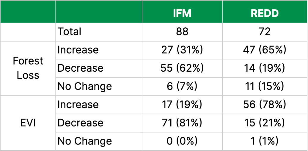
Out of the 88 IFM projects selected, 27 have increased in pixels indicating forest loss, equating to 31%, and 55 have shown a reduction in forest loss at 63% (and 6 projects / 7% show no change since crediting began). 65% of the 72 REDD projects (47 projects) exhibit a higher amount of forest loss, compared to only 19% (14 projects) decreasing and 15% (11 projects) with no change.

Although 63% of IFM projects show a decrease in forest loss, 81% of the same projects show a decrease in EVI, which may seem counterintuitive and conflicting at first glance. There are many potential explanations for these figures, such as seasonal variation where there has been a reduction in forest loss since credit issuance began but the apparent health of the vegetation changes throughout the year. Alternatively, this could be a result of forest regeneration or a change in vegetation type, which will show a decrease in forest loss with a concurrent decrease in EVI for the same area (for example if there is a change from dense forest to more open woodland).
The opposite seems true for REDD projects, where nearly two thirds have increased forest loss with just over three quarters increasing EVI values - whilst these areas show continued loss of forest cover in the project area, the actual health of the vegetation may not be as impacted as expected. REDD projects appear to be more successful at increasing EVI values than IFM projects - there is a greater relative difference when EVI increases compared to when EVI decreases, but the opposite occurs for IFM projects.
There may be a number of reasons for this observation, such as positive by-products of the projects’ goals. IFM focuses primarily on addressing and mitigating forest loss by improving management strategies, which facilitates the conservation of existing forests and the prevention of further loss. REDD projects, however, can focus on increasing vegetation density and biodiversity alongside its main goal of forest conservation and preventing degradation.
Extreme Weather Events: Rimba Raya Case Study
For both REDD and IFM projects, when forest loss increased after project crediting began, it did so to a greater magnitude than when forest loss decreased. To understand the causes of this pattern, we selected REDD project Rimba Raya Biodiversity Reserve Project in the Central Kalimantan region of Indonesia (VCS674) as a case study.
Rimba Raya is the largest retiring project, responsible for 24.3 million retirements since 2009 for an average estimated offer price of $5.78 per credit. Well-known credit buyers such as AUDI, Volkswagen and Allianz have paid an estimated $40m for credits from the project.
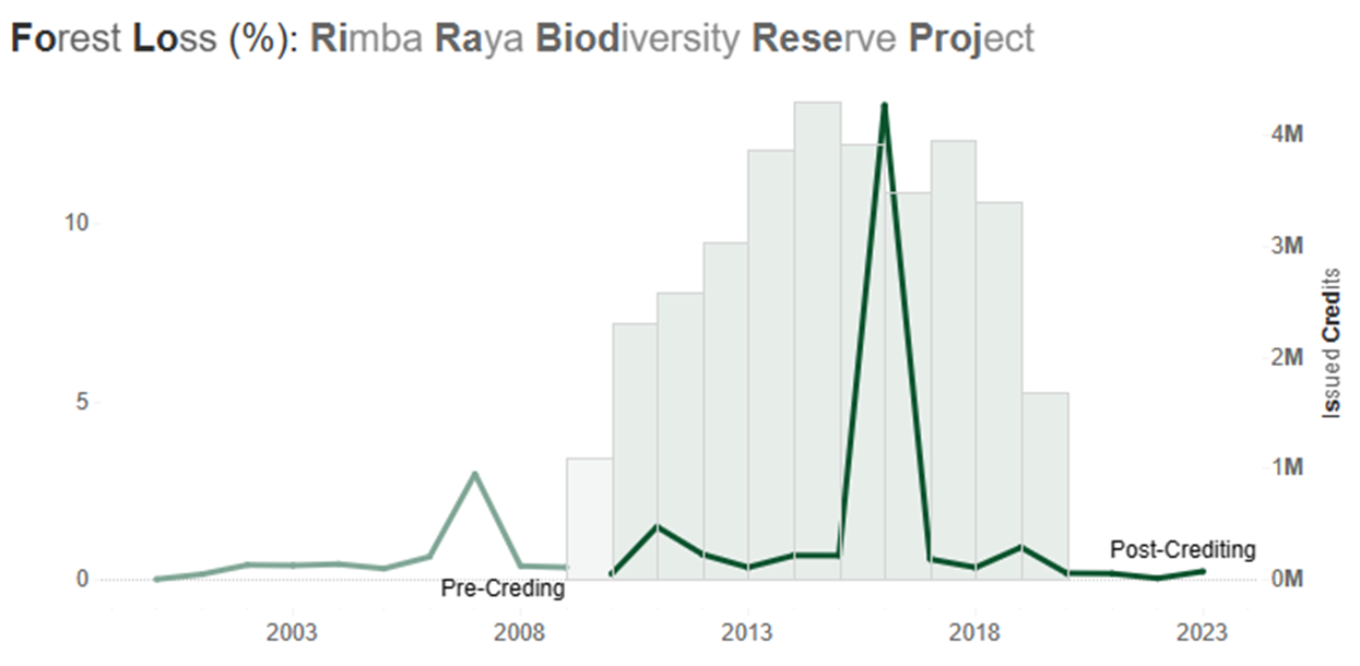
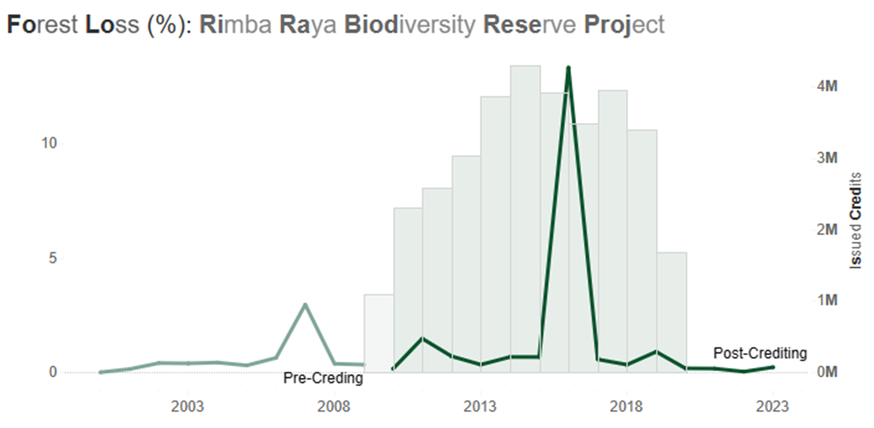
The project began issuing credits in 2009, and experienced a huge increase in forest loss in 2016: the value increased from 0.67% in 2015 to 13.3% in 2016, equating to an increase of nearly 2000%. The cause of this immense surge was an extreme El Niño weather event causing above average dry conditions, paired with slash-and-burn practices of nearby forest and degraded peatland which resulted in one of the most severe fire seasons observed by NASA’s Earth Observing System satellites since the early 2000s.

Figure 1: plot of forest loss of the Rimba Raya Biodiversity Reserve Project, Indonesia, showing a huge spike in forest loss in 2016 and subsequent decrease in credit issuances.

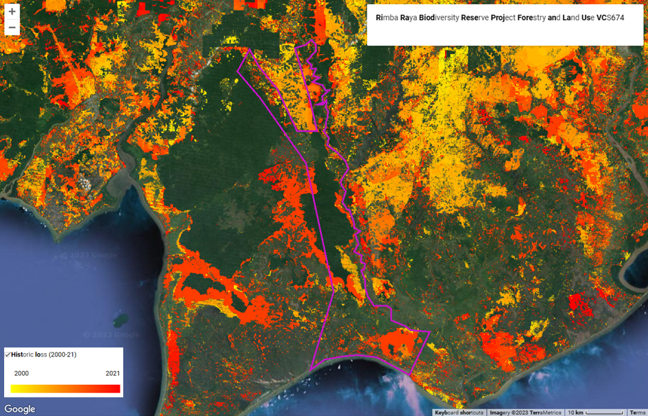
Figure 2: Rimba Raya project area highlighted in pink with historical forest loss shown from 2000 to 2021. A large area of the project area was lost in forest fires in the 2015-16 period, displayed in dark orange.
Conclusion
After further analysis of AlliedOffsets’s data of both IFM and REDD projects, it appears that the suitability of each sub-sector depends on the objectives, values, and requirements of the end-user of credits – whilst IFM projects appear to be more effective at reducing forest loss, REDD projects have an added advantage of improving the health and biodiversity of existing forests. Further, increases in forest degradation may not be related to project management, but rather exogenous environmental and climatic factors (such as regional forest fires, extreme weather events, disease, etc.) may impact projects’ efforts.
The takeaway from this is that whilst these events aren’t common, their frequency and severity are increasing as a result of climate change. It is also imperative to consider that these occurrences will introduce a skew in forest loss values for REDD projects due to their size - it's important to keep in mind that these events ca affect the project negatively, even if the project is otherwise succeeding in preventing forest loss.
Whist it is important to observe and understand overall trends in the data, the most effective and comprehensive method is to delve into individual projects. This way, we can have a thorough grasp of the reasoning behind those trends, leading us towards a more accurate portrayal of the situation. AlliedOffsets has over 450 nature-based projects available for such analysis on our extensive Geospatial dashboard, which can be accessed alongside a multitude more data on the premium dashboard. Sign up for a demo here.
